Free Consultation!

Home
Services Overview
Our Team and Credentials
Pricing and Subscription
Mapping & RTK Service
CINEMATIC AERIAL SERVICES
Hybrid Aerial Solutions
Archipelago Industries
Home
Services Overview
Our Team and Credentials
Pricing and Subscription
Mapping & RTK Service
CINEMATIC AERIAL SERVICES
Hybrid Aerial Solutions
More
  • Home
  • Services Overview
  • Our Team and Credentials
  • Pricing and Subscription
  • Mapping & RTK Service
  • CINEMATIC AERIAL SERVICES
  • Hybrid Aerial Solutions
Archipelago Industries
  • Home
  • Services Overview
  • Our Team and Credentials
  • Pricing and Subscription
  • Mapping & RTK Service
  • CINEMATIC AERIAL SERVICES
  • Hybrid Aerial Solutions

Precision Mapping & RTK Data Services

PRECISION MAPPING & RTK DATA SERVICES

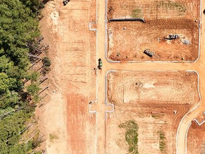
Survey-grade aerial mapping, measurements, and progress documentation for construction, land development, and government projects.

Accurate Data You Can Build Decisions On

Precision Mapping & RTK

Our precision mapping services provide reliable aerial data designed for planning, measurement, monitoring, and reporting. Using RTK-enabled positioning and disciplined flight workflows, we deliver consistent results you can trust throughout the lifecycle of your project.

Precision Mapping Services Include:

  • Orthomosaic mapping
  • RTK-enabled, survey-grade accuracy
  • 3D terrain & surface models
  • Stockpile & volume calculations
  • Site measurements & documentation
  • Construction progress mapping
  • Change detection & comparisons

Survey-Grade Precision with RTK Positioning

RTK (Real-Time Kinematic) positioning allows our systems to achieve centimeter-level accuracy. This ensures that data collected today aligns accurately with data collected weeks or months later — making it ideal for progress tracking, volume analysis, and compliance reporting.

  • Repeatable results over time
  • Reduced measurement uncertainty
  • Fewer ground control requirements
  • Increased confidence in reporting

Find out more

Who Uses Precision Mapping Services

  • Construction & engineering firms
  • Government & land management agencies
  • Developers & planners
  • Infrastructure & utility projects

Pricing & Engagement

Pricing and engagement options

Precision mapping services are offered as project-based deliverables or ongoing subscription services.


  • Project-based mapping — Starts at $1,200
  • Ongoing monitoring subscriptions — Starts at $750/month

Final pricing is based on site size, scope, frequency, and reporting requirements.

Need Reliable Site Data You Can Trust?

Let’s discuss your project goals and determine the right mapping approach.

Request a Consultation

Copyright © 2026 Archipelago Industries - All Rights Reserved.

Powered by

This website uses cookies.

We use cookies to analyze website traffic and optimize your website experience. By accepting our use of cookies, your data will be aggregated with all other user data.

Accept